

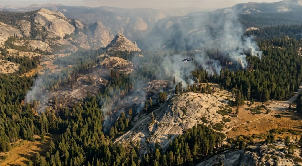
The Dome Fire in Yosemite National Park has reached 5,585 acres and 39% containment, more than two weeks after it was first reported near Chilnualna Falls on September 15. Cooler temperatures and higher humidity have helped firefighters strengthen containment lines, but the fire continues to grow, moving primarily north and northeast through the Yosemite Wilderness.
Yosemite remains open and operating normally across most of the park, but the fire continues to affect transportation and recreation access in the southern portion of the park. Glacier Point Road remains closed, while the Chilnualna Falls Trail and trails extending from the top of the falls toward Buena Vista and Crescent Lakes remain closed because of the fire. The Ostrander Trail and areas south of it are also closed.
The incident has also had a tragic human cost. On September 20, helicopter pilots Ryan Cutter and Greg King died when their aircraft crashed during water-dropping operations on the fire. Their deaths have added a significant dimension to an incident that is already affecting thousands of acres of wilderness and an important fall recreation period.
The latest investigation has also identified the fire’s cause. Fire officials now list the cause as a human-caused abandoned campfire. The National Park Service has asked anyone who may have information about a campfire near the Chilnualna Falls Trail between September 9 and September 15 to contact investigators.
The Dome Fire Has Continued To Expand Inside Yosemite Wilderness
The Dome Fire was first reported at approximately 7 a.m. on September 15, north of Wawona Dome and roughly a quarter-mile from Chilnualna Falls. Since then, its footprint has expanded steadily through rugged terrain in the southern portion of Yosemite.
The latest NPS update from September 30 recorded 242 acres of additional growth since the previous morning, bringing the official NPS figure to 5,585 acres and 39% containment. Firefighters have been able to increase containment faster than the fire has expanded, a sign that control efforts are making progress even though the perimeter continues to grow.
CAL FIRE’s September 30 incident update lists the fire at 5,739 acres, also with 39% containment. The difference reflects the fact that agencies can update incident acreage at different times as mapping and perimeter information are refined. CAL FIRE identifies the fire as human-caused by a campfire and reports two firefighter fatalities.
| Measure | September 30, 2026 |
|---|---|
| NPS reported acreage | 5,585 acres |
| CAL FIRE reported acreage | 5,739 acres |
| Containment | 39% |
| Fire start | September 15, 2026 |
| Fire cause | Abandoned campfire |
| Firefighter fatalities | 2 |
| Primary movement | North and northeast |
The fire is burning within the Yosemite Wilderness, where crews face a very different operating environment from developed portions of the park. Natural barriers, steep terrain, granite formations and previously burned areas all influence the way firefighters establish containment lines.
The National Park Service reports that crews have used granite rock as natural barriers while reinforcing control lines around the fire perimeter. Mules and helicopters have also been used to move hose, equipment, food and other supplies into the wilderness.
For broader context on how wildfire and recreation infrastructure interact, ITPR wildfire and park access coverage tracks the growing relationship between fire management, public lands and outdoor recreation.
Cooler Weather Is Helping Firefighters Gain Containment
Weather has become an important factor in the latest progress.
Cooler temperatures and higher humidity have helped firefighters reinforce containment lines around the Dome Fire. On September 30, the NPS reported that weather conditions allowed crews to strategically use firing operations to connect the fire perimeter to established containment lines.
That progress does not mean the fire has stopped spreading.
The latest NPS report says the fire continues to grow, but containment is increasing at a faster rate. Weather conditions are expected to become warmer and drier through the end of the week, although relatively calm winds should give firefighters opportunities to continue strengthening control lines.
The changing weather illustrates why acreage alone does not fully describe the operational situation.
A fire can continue adding acres while simultaneously becoming increasingly surrounded by containment lines. Conversely, a relatively small amount of growth can become more significant if accompanied by stronger winds, lower humidity or increased spotting.
The Dome Fire’s location adds another complication because much of the activity is occurring in wilderness terrain where crews must carefully balance direct firefighting operations with difficult access.
The Fire Is Moving Through The 2017 Empire Fire Footprint
One of the most significant geographic features of the Dome Fire is its movement through an area previously affected by the 2017 Empire Fire.
NPS updates have repeatedly reported that the Dome Fire is moving north and northeast through the old Empire Fire footprint. The area contains substantial dead and fallen trees, which can throw embers ahead of the active fire and create new spot fires.
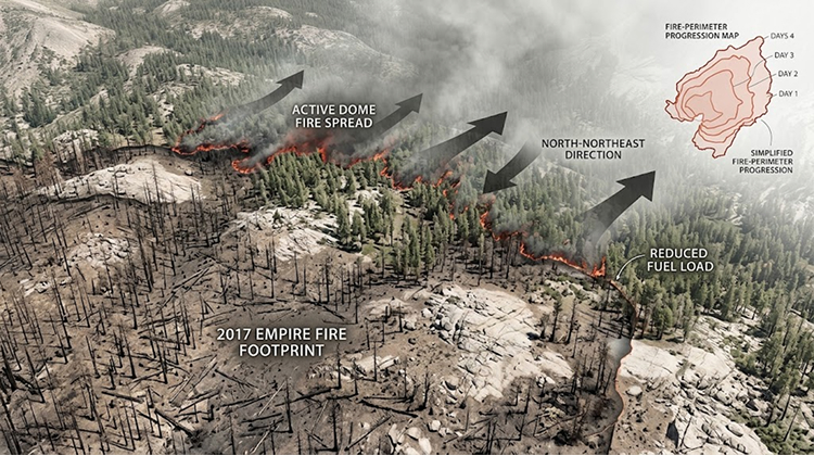
This creates a complex fire environment.
Standing and fallen dead trees can provide additional fuel and allow embers to travel beyond the primary fire edge. At the same time, the previous burn area and exposed granite can create portions of the landscape where fire spread is slower.
Firefighters are taking advantage of those natural features as they build and widen containment lines.
The NPS has identified areas near Bridalveil Creek, Empire Meadows and Horse Ridge as important locations for containment work. Crews have been connecting handlines, widening control lines and using granite formations as natural barriers.
This approach is particularly important in wilderness because heavy mechanical equipment cannot simply be used everywhere.
Instead, crews may have to rely on hand crews, pack animals, helicopters and carefully selected natural features to move equipment and establish lines.
Glacier Point Road Remains Closed
The most visible transportation impact is the closure of Glacier Point Road.
The road remains closed because smoke has reduced visibility and because the route is being used to support firefighting operations. The NPS says the road will reopen when conditions allow.
The closure does not mean Glacier Point itself is completely inaccessible.
The Four Mile Trail and Panorama Trail remain open to hikers, providing alternative access toward the Glacier Point area. Visitors who were already staying overnight at Glacier Point when the road closure began have been allowed to exit after the closure.
This distinction illustrates how Yosemite is managing access during the incident.
Rather than closing the entire park, officials are isolating areas directly affected by fire, smoke or firefighting operations while keeping other recreation corridors available.
The NPS Yosemite fire information provides the latest closure and operational information for visitors because conditions can change as the fire perimeter and smoke conditions evolve.
Chilnualna Falls Trails Face Longer-Term Restrictions
The recreation impacts extend beyond the road system.
The Chilnualna Falls Trail is closed, as are trails from the top of Chilnualna Falls toward Buena Vista and Crescent Lakes. The Ostrander Trail and areas south of it are also closed.
These closures are important because the affected routes provide access to a network of wilderness destinations rather than a single isolated viewpoint.
Chilnualna Falls is located in the Wawona area, one of the southern gateways to Yosemite. The trail system provides visitors with access to waterfalls, forested mountain terrain and higher-elevation destinations.
The closures therefore remove several recreation options at a time when fall weather normally attracts hikers and backpackers.
At the same time, the NPS continues to distinguish between closed areas and the rest of Yosemite. The park remains open, and unaffected trails and developed areas continue to operate.
That targeted approach helps maintain access while keeping visitors away from areas where smoke, fire activity or firefighting operations create additional hazards.
Firefighting Operations Require A Large Logistics Network
The Dome Fire is also demonstrating the logistical complexity of fighting a large wildfire inside a national park.
NPS updates have described the use of pack mules and helicopters to transport water, fuel, food, fire hose and equipment to crews operating in remote terrain. On September 30, the park reported that mules and helicopters were assisting with backhauling hose and equipment.
That logistics network becomes essential when roads cannot reach the active fire perimeter.
Instead of simply moving crews by vehicle, incident managers must establish supply chains that can operate across wilderness terrain. Pack strings can carry equipment along narrow routes, while helicopters provide aerial transportation and water-delivery capabilities.
The operation also requires continuous crew rotation.
The NPS reported that new fire crews continue to arrive as crews reach their maximum deployment periods. This allows firefighting operations to continue while reducing the risks associated with extended deployments.
The scale of the operation is reflected in earlier incident updates. On September 28, the fire was being managed with 808 personnel, while 781 personnel were assigned on September 26.
The workforce therefore represents a substantial temporary presence inside a wilderness landscape that normally receives visitors primarily for recreation and solitude.
Wawona And Yosemite West Remain Part Of The Fire Strategy
While much of the Dome Fire is burning in wilderness, nearby communities also require protection.
NPS updates have described structure firefighters working around Wawona and Yosemite West, including clearing brush around homes, checking fire hydrants and maintaining road access.
The September 30 update states that no roads, buildings or utilities are under immediate threat.
That status represents an important distinction from the fire’s continued growth.
A wildfire can remain active and add acreage without directly threatening developed infrastructure. Fire managers can use containment lines, natural barriers and strategic operations to keep the fire within areas where it poses less immediate risk to buildings and utilities.
For Wawona and Yosemite West, maintaining roads and preparing defensible areas around structures remains an important part of the overall incident response.
The situation also demonstrates why recreation management and community protection often overlap in national parks. Roads serving visitors may also be essential routes for emergency personnel, residents and firefighters.
The Fire’s Human Cause Has Changed The Story
Investigators have now identified an abandoned campfire as the cause of the Dome Fire.
The fire began on September 15 near the Chilnualna Falls area, and the National Park Service previously asked visitors who had been on the trail between September 9 and September 15 to report whether they had seen anyone with a campfire. Officials are now listing the cause as “human — abandoned campfire.”
The identification of the cause does not mean investigators have publicly identified the person who left the fire unattended.
The NPS has asked anyone with information to contact its tip line. Officials have indicated that the responsible person could potentially face federal charges, but no suspect has been publicly identified.
The finding is especially significant because Yosemite had already implemented fire restrictions at elevations of 8,000 feet and below beginning August 1. The Dome Fire therefore occurred during a period when wildfire precautions were already heightened.
The cause also reinforces the connection between visitor behavior and wildfire risk in heavily visited public lands.
Two Aviation Deaths Have Added A Tragic Dimension
The Dome Fire response has also resulted in two firefighter fatalities.
On September 20, helicopter pilots Ryan Cutter and Greg King died when their aircraft crashed during water-dropping operations on the fire. Both were conducting aerial firefighting work when the incident occurred.
Cutter was identified by family members as a pilot with a background in high-risk aviation work. King was a contract helicopter pilot from Alaska who lived in Palmer and was a stepfather to two children.
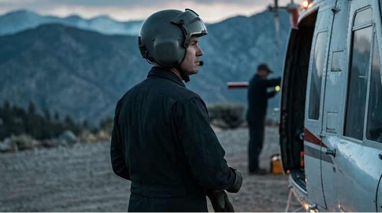
Their deaths highlight the risks associated with aerial firefighting, particularly in steep mountain environments where aircraft operate close to terrain, smoke and changing weather.
Aerial resources remain an important component of the Dome Fire response because much of the fire is located in wilderness terrain where ground access is difficult.
The continuing use of helicopters in the incident therefore comes with a heightened awareness of the risks involved for pilots and firefighters.
Smoke Continues To Influence Recreation Conditions
Fire behavior is only one factor affecting visitors.
Smoke from the Dome Fire has periodically affected air quality across portions of Yosemite, including Wawona, Yosemite Valley and Tuolumne Meadows. Earlier NPS smoke outlooks reported periods of air quality categorized as unhealthy for sensitive groups in several locations.
Smoke can affect recreation even when a trail is nowhere near the active fire perimeter.
Hikers may encounter reduced visibility, respiratory irritation and changing conditions as wind direction shifts. For that reason, the continued closure of Glacier Point Road is based partly on visibility and operational considerations rather than direct fire encroachment on the roadway.
Visitors who are planning activities in Yosemite therefore need to monitor both fire closures and daily air-quality information.
The park’s status can change without the entire park closing.
Yosemite’s Fall Recreation Season Is Being Reshaped
Late September is normally an important period for Yosemite recreation.
Cooler temperatures can make hiking more comfortable, fall colors begin developing at higher elevations and visitors often take advantage of reduced summer crowds. The Dome Fire is now affecting part of that seasonal recreation pattern.
The closed Chilnualna Falls and Ostrander Trail areas remove access to wilderness routes during a period when conditions would otherwise be favorable for hiking and backpacking.
Glacier Point Road’s closure also changes how visitors reach one of Yosemite’s most recognizable viewpoints, although hikers can continue using the Four Mile and Panorama trails.
The situation illustrates how wildfire can have an effect on recreation that extends well beyond the acreage burned.
A fire can alter transportation, air quality, trail availability, visitor circulation and staffing even when developed areas remain physically intact.
For Yosemite, maintaining access to unaffected areas while protecting visitors from active fire operations has become the central management challenge.
The Next Phase Will Depend On Containment And Weather
The Dome Fire’s September 30 status represents progress, but the incident remains active.
The NPS reports that containment is increasing faster than fire growth, and crews are continuing to reinforce lines. Weather is expected to become warmer and drier through the end of the week, although calm winds should allow firefighters to continue making progress.
That means conditions remain dynamic.
The immediate objective is to strengthen containment lines around the northern and northeastern portions of the fire while taking advantage of natural barriers and favorable terrain.
The longer-term recreation question is when those containment efforts will allow roads and trails to reopen safely.
Glacier Point Road is expected to reopen when conditions permit, but the NPS has not provided a specific reopening date. The Chilnualna Falls and Ostrander Trail closures likewise remain tied to fire conditions and operational requirements rather than a predetermined calendar date.
The Dome Fire has therefore created a temporary but substantial reconfiguration of Yosemite’s southern recreation network.
At 5,585 acres and 39% containment, the fire is still an active wilderness incident. Yet the park continues operating across most of its territory, demonstrating the targeted approach Yosemite is using to separate active fire zones from areas where recreation can continue.
For visitors, that means Yosemite’s status cannot be reduced to a simple open-or-closed designation. The park remains open, but specific roads, trails and wilderness areas are restricted while firefighters work to contain the fire and protect surrounding communities.
As containment progresses, the next milestones will be measured less by acreage alone and more by whether crews can secure the fire perimeter, stabilize smoke conditions and safely return access to the affected recreation corridors.