

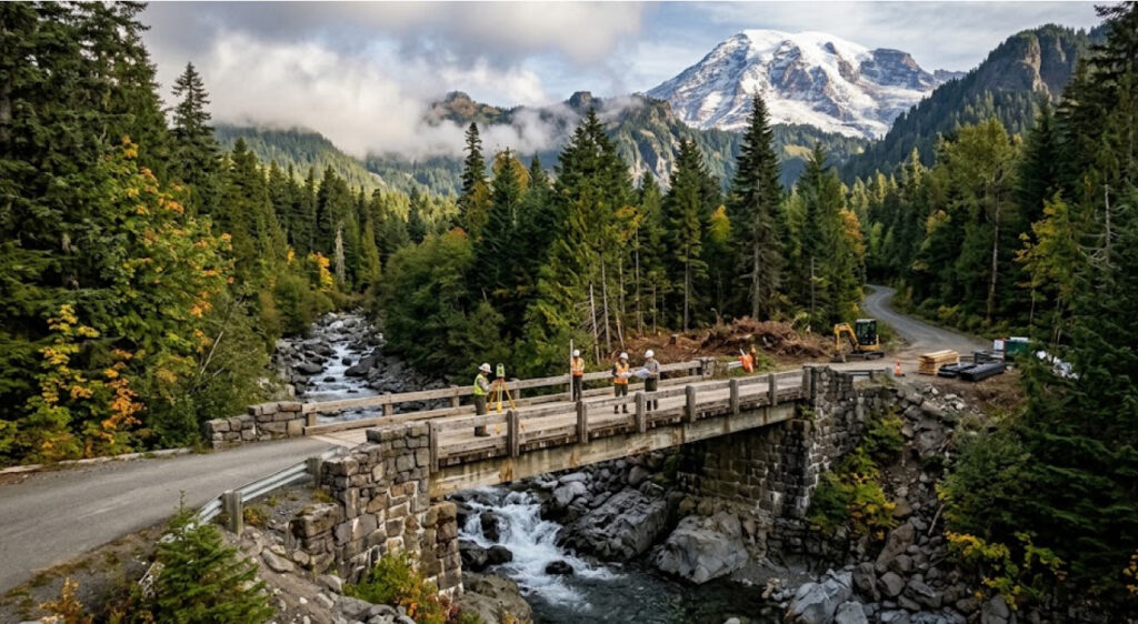
Mount Rainier National Park is preparing for a major infrastructure project that will replace the historic Fryingpan Creek Bridge, a 1931 structure along White River Road that provides an important connection to the park’s White River Campground, Sunrise Developed Area and surrounding trails. Preparation work is scheduled to begin September 28, 2026, while the main bridge construction is expected to take place during the 2027–2029 seasons. The National Park Service says the existing bridge has exceeded its life expectancy and that changes in the riverbed have reinforced the need for a newly designed structure. Mount Rainier construction updates provide the current project schedule and visitor-access information.
The project is more than a routine bridge replacement. Fryingpan Creek Bridge is part of the historic road system that shaped access to Mount Rainier during the early development of the national park. At the same time, it carries modern transportation demands that the original 1931 structure was never designed to handle indefinitely. The replacement therefore has to address structural condition, river behavior, visitor access and the historic character of the surrounding roadway.
A 1931 Bridge Is Approaching The End Of Its Service Life
Fryingpan Creek Bridge was constructed in 1931 by the Bureau of Public Roads and the National Park Service. The existing structure is an unusual three-hinged arch bridge with solid-web arch girders, masonry-veneered abutments and a 127-foot arch span. It is approximately 28 feet wide.
Nearly a century after its construction, the bridge is reaching the point where continued rehabilitation is no longer considered the most practical long-term solution.
The National Park Service’s project documentation identifies the bridge as being of “major” concern in the most recent Federal Highway Administration bridge inspection report. The structure remains safe for continued use under reduced loads and frequent inspections, but the agencies determined that extensive rehabilitation or replacement is necessary to preserve reliable access to the northeastern portion of the park.
That distinction is important. The bridge is not being replaced because it has suddenly become unusable. Instead, the project reflects a common public-infrastructure problem: a structure can remain operational while simultaneously reaching a point where its long-term condition, capacity and maintenance requirements make replacement the more sustainable option.
The challenge becomes more significant in a national park because replacing a historic structure involves more than meeting modern engineering standards. The new bridge must also fit the character of the historic roadway and landscape.
The Bridge Is Critical To Sunrise And White River Access
Fryingpan Creek Bridge is located in the northeast section of Mount Rainier National Park, approximately three miles west of the White River Entrance and Ranger Station. It sits along the road providing access toward the White River Campground and Sunrise.
The road is particularly important because the National Park Service describes the 15-mile Sunrise Road as the sole vehicular connection from Mather Memorial Highway, or Highway 410, to the Sunrise Developed Area and White River Campground within the park.
That makes the bridge a transportation bottleneck with consequences extending well beyond the immediate crossing.
| Project Detail | Current Information |
|---|---|
| Original bridge | 1931 |
| Historic arch span | 127 feet |
| Bridge width | 28 feet |
| Location | White River Road / Sunrise Road corridor |
| Preparation begins | September 28, 2026 |
| Main construction | 2027–2029 seasons |
| Bridge condition | Major concern in latest FHWA inspection |
| Replacement alignment | Approximately 50 feet downstream |
The Fryingpan Creek Bridge project page explains that the new structure is intended to preserve long-term vehicular access while addressing structural and river-related issues.
For visitors, that means the bridge is part of the infrastructure that makes access to one of Mount Rainier’s most recognizable high-country destinations possible.
The New Bridge Will Move Downstream
One of the most important design decisions is that the replacement bridge will not simply occupy the exact footprint of the existing structure.
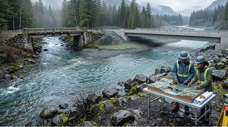
The National Park Service selected Alternative B, which calls for construction of a new bridge on a new alignment approximately 50 feet downstream from the existing bridge. The selected design is intended to improve the relationship between the crossing and the Fryingpan Creek channel while reducing the constraints created by the current bridge abutments.
The final project documentation describes a new bridge approximately 220 feet long, with a waterway opening of roughly 207 feet from abutment face to abutment face. The longer crossing is designed to span the 100-year floodplain while placing the new abutments outside the ordinary high-water mark.
This is a significant engineering change compared with the existing 127-foot arch span.
The longer bridge responds directly to the relationship between infrastructure and river movement. Instead of forcing the waterway through a comparatively constrained crossing, the new structure will provide a wider opening beneath the road.
That approach is particularly relevant in a mountain environment where streams can experience substantial changes in flow and sediment movement.
Riverbed Changes Are Part Of The Problem
The need for replacement is not based solely on the age of the bridge.
The National Park Service says the riverbed has changed, requiring a newly designed structure. The project’s environmental documents similarly examine the relationship between the existing bridge, floodplain and channel migration zone.
The selected alternative is designed to expand the channel migration zone and floodplain beneath the crossing rather than continuing to constrain the river with the existing bridge configuration.
That matters because a bridge is not an isolated object. Its abutments, roadway approaches and foundation locations influence how water moves during high-flow events.
By placing the new abutments farther from the active channel, the project is intended to give the river more room beneath the crossing while reducing the vulnerability of the new infrastructure.
For a park increasingly planning around severe weather, flooding and infrastructure resilience, that represents a broader shift in how transportation projects are designed.
The National Park Service’s Fryingpan Creek environmental assessment describes the project as a way to provide sustainable vehicular access while meeting modern bridge safety and accessibility requirements.
Preparation Work Begins In September 2026
The first visible phase of the project begins September 28, 2026.
According to the park’s current construction schedule, crews will work on tree clearing and salvaging as well as removal of existing masonry. The initial preparation period is expected to continue through October 31, weather permitting, with work scheduled from 6 a.m. to 6 p.m.
Visitors traveling along White River Road should expect traffic delays of up to 30 minutes because of one-lane traffic during the preparation work. The Summerland Trailhead parking area will also close, with no parking permitted on either side of the bridge.
The Summerland spur trail will be closed as well.
The timing is significant because Mount Rainier’s construction season is short. Heavy winter snowfall limits the period during which many infrastructure projects can proceed, meaning crews have to accomplish substantial work during the relatively narrow snow-free season.
The park’s construction page states that there will be no work from November 2026 through April 2027 because of the regular seasonal closure of roads.
This seasonal rhythm is one reason the bridge replacement extends across three construction seasons rather than being treated as a single continuous calendar-year project.
Summerland Will Remain Accessible By An Alternative Route
The closure of the Summerland Trailhead does not eliminate access to Summerland itself.
The National Park Service says hikers can reach Summerland via the Wonderland Trail, with limited parking available at White River Campground.
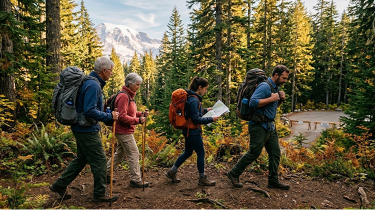
That alternative matters because Summerland is one of Mount Rainier’s popular destinations for visitors seeking subalpine scenery and views of Mount Rainier and Little Tahoma.
Under normal conditions, the Summerland Trail is an 8.4-mile round-trip hike with approximately 2,100 feet of elevation gain. The standard trailhead is located near the Fryingpan Creek bridge, but the project will make parking there unavailable beginning September 28 and continuing through the construction period.
Visitors using the alternative access point should therefore expect a different logistical experience rather than assuming the normal trailhead will remain available.
The park is also advising visitors to plan ahead because the alternate parking area is limited.
The Project Has To Preserve A Historic Roadway
Replacing the bridge also means working within a nationally significant historic landscape.
Fryingpan Creek Bridge is a contributing structure within the Mount Rainier National Historic Landmark District, and the road itself forms part of the park’s historic transportation system. Project documents emphasize the need for the new structure to remain compatible with the historic character of the area.
This creates a design challenge that would not exist in the same form for an ordinary modern highway bridge.
The new bridge must accommodate contemporary engineering requirements without visually disconnecting the roadway from the architectural language established during Mount Rainier’s early park-development period.
The environmental decision documents state that the selected alternative incorporates mitigation measures and best management practices developed through environmental review and consultation. Changes to the trailhead parking design were also made following public comments and consultation with the U.S. Fish and Wildlife Service, National Marine Fisheries Service and Washington State Historic Preservation Office.
The process illustrates how infrastructure decisions inside national parks involve multiple layers of review. Engineering, resource protection, historic preservation and visitor access all influence the final design.
Construction Will Affect A Larger Trail Network
The bridge is directly associated with several recreation opportunities beyond the roadway itself.
The Summerland Trailhead provides access to the Summerland Trail and connects with the broader Wonderland Trail system. Current park trail information states that access to Summerland remains available through the Wonderland Trail despite the closure of the Fryingpan Creek Trailhead parking area.
The project will therefore change how visitors approach the area rather than eliminating the destination altogether.
This distinction is important for understanding infrastructure projects in protected landscapes. A temporary closure at one access point can shift pressure onto another trailhead, alter parking demand and change the amount of time visitors spend reaching a destination.
For ITPR, the project provides a useful example of how park infrastructure and recreation infrastructure are effectively the same system. A bridge replacement is a transportation project, but its consequences extend directly into hiking, camping, trail access and visitor use.
ITPR’s outdoor recreation infrastructure coverage provides additional context on how public agencies are adapting aging recreation systems to current visitor and environmental demands.
The Multi-Year Timeline Is A Long-Term Access Strategy
The main construction period is currently estimated for the 2027–2029 seasons.
That timeline may initially appear lengthy for a single bridge, but the project involves more than removing one structure and installing another. Crews must manage the historic roadway, river channel, floodplain, construction access, trailhead changes and environmental mitigation while working within a seasonal mountain construction window.
The National Park Service previously explained that maintaining seasonal public access was a central consideration in the project. Earlier project planning anticipated continued access toward Sunrise and White River during construction, with one lane of Sunrise Road available and temporary delays of approximately 20–30 minutes.
The current project schedule continues to emphasize long-term access, even as the Summerland Trailhead itself remains closed.
The result will be a period of inconvenience followed by a transportation crossing designed to serve the park for decades.
A Bridge Replacement Becomes Part Of Mount Rainier’s Infrastructure Future
Fryingpan Creek Bridge represents one piece of a much larger infrastructure challenge at Mount Rainier National Park.
The park is simultaneously managing roads, campgrounds, wastewater systems, trailheads, bridges and other visitor facilities, many of which were constructed decades ago. Heavy winter conditions compress the construction season, while increasing expectations for safety, accessibility and environmental resilience raise the standard for replacement projects.
The Fryingpan Creek project shows how those demands intersect.
A 1931 bridge is being replaced because its service life is nearing its practical limit and the river environment has changed. The replacement will be longer, move downstream and provide a larger waterway opening. The Summerland Trailhead will temporarily close, but the destination will remain accessible through an alternative route. Construction will be phased around Mount Rainier’s winter conditions and historic landscape.
For visitors, the first major change arrives on September 28, 2026, when preparation work begins and the Summerland parking area closes. For the park, however, that date marks the beginning of a much longer effort to modernize a critical connection without sacrificing the historic character and natural setting that define the Sunrise and White River corridor.
The bridge that emerges from the 2027–2029 construction seasons will serve a different engineering standard from its 1931 predecessor. Its larger span and downstream alignment are intended to give both the road and Fryingpan Creek more room to function safely, while the surrounding trail network remains connected through alternative access.